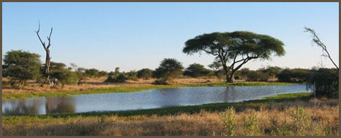
Southern African Information
-
South Africa
-
Free State
The Free State lies in the heart of South Africa, with the Kingdom of Lesotho nestling in the hollow of its bean-like shape. Lying between the Vaal River in the north and the Orange River in the south, the region is one of flat, rolling grassland and crop fields, rising to lovely sandstone mountains in the northeast.
The province is the granary of South Africa, with agriculture central to its economy, while mining on the rich goldfields reef is its largest employer. Bloemfontein is the capital, and home to South Africa's Supreme Court of Appeal, the University of the Free State and the Central University of Technology.
Important towns include Welkom, the heart of the goldfields and one of the few completely preplanned cities in the world; Odendaalsrus, another gold-mining town; Sasolburg, which gets its name from the petrochemical company Sasol; Kroonstad, an important agricultural, administrative and educational centre; Parys, on the banks of the Vaal River; Phuthaditjhaba, a vast and sprawling settlement known its beautiful handcrafted items; and Bethlehem, gateway to the Eastern Highlands of the Free State.
With a total area of 129 480 square kilometres, the Free State is roughly the size of Nicaragua. It's the country's third-largest province, only slightly bigger than the Western Cape, and taking up 10.6% of South Africa's land area.
Its 2006 population was an estimated 2.9-million people. Two-thirds speak Sesotho, the language of neighbouring Lesotho, followed by Afrikaans and a sprinkling of isiXhosa.
A summer-rainfall region, the Free State can be extremely cold during the winter months, especially towards the eastern mountainous regions. The western and southern areas are semi-desert.
A beautiful range of hills near Parys in the northern Free State is actually part of the Vredefort Dome, the largest visible meteor-impact site in the world. Formed 2-billion years ago when a meteorite 10 kilometres wide slammed into the earth, the Vredefort Dome is one of South Africa's seven Unesco World Heritage sites.
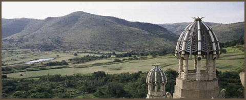
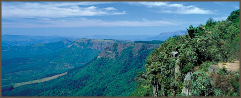
In the northeastern Free State, nestled in the rolling foothills of the Maluti mountains, the Golden Gate Highlands National Park is the province's prime tourist attraction. The park gets its name from the brilliant shades of gold cast by the sun on the spectacular sandstone cliffs, especially the imposing Brandwag or Sentinel Rock, which keeps vigil over the park.
The sandstone of this region has been used for the lovely dressed-stone buildings found on the Eastern Highlands, while decoratively painted Sotho houses dot the grasslands. Some of South Africa's most valued San (Bushman) rock art is found in the Free State, particularly in the regions around Bethlehem, Ficksburg, Ladybrand and Wepener.
South Africa's national road, the artery between Gauteng and the Western and Eastern Cape, cuts through the centre of the Free State.
Before democracy in 1994 the province was known as the Orange Free State. An independent Boer republic in the 19th century, it became a province under the Union of South Africa in 1910.
-
North West Province
North West lies in the north of South Africa on the Botswana border, fringed by the Kalahari desert in the west, Gauteng province to the east, and the Free State to the south. It is known as the Platinum Province for the wealth of the metal it has underground.
Mafikeng (previously Mafeking) is the capital, and best known for the famous siege during the Anglo-Boer War, which ended in a decisive victory for the British and made a hero of Robert Baden-Powell.
The city lies near the Botswana border and forms a single urban area with its neighbouring town, Mmabatho. Potchefstroom and Klerksdorp are the biggest cities in the province; other main towns are Brits and Rustenburg.
Most economic activity is concentrated in the southern region between Potchefstroom and Klerksdorp, as well as Rustenburg and the eastern region, where more than 83.3% of the province's economic activity takes place.
North West has a number of major tourist attractions, including the internationally famous Sun City, the Pilanesberg National Park, the Madikwe Game Reserve and the Rustenburg Nature Reserve.
With a total area of 106 512 square kilometres, North West is slightly smaller than the US state of Pennsylvania. It's the country's fourth-smallest province, taking up 8.7% of South Africa's land area and with a mid-2006 population of 3.4-million people.
Two-thirds of the people speak Setswana, the language of neighbouring Botswana, with the rest speaking Afrikaans and isiXhosa. Only 35% of the population is urbanised.
The province was created in 1994 by the merger of Bophuthatswana, one of the apartheid-era bantustans or "homelands", and the western part of province of Transvaal.
The landscape is largely flat regions of scattered trees and grassland. The Magaliesberg mountain range in the northeast extends about 130 kilometres from Pretoria to Rustenburg, while the Vaal River forms the province's southern border.
A summer-rainfall region, temperatures range from up to 31° C in summer to as little as 3° C in winter.
North West's most famous attraction is the Sun City complex, which lies next to the Pilanesburg National Park. Sun City is one of the world's biggest entertainment centres, with a casino, an 18-hole golf course, theatres and concert halls, beaches and a wave pool at the Valley of the Waves, a meticulously reconstructed tropical rainforest, and a number of world-class hotels that include the remarkable Palace of the Lost City.
Portions of two of South Africa's seven Unesco World Heritage sites fall within the borders of North West: the Vredefort Dome, the world's largest visible meteor-impact crater, and the Taung hominid fossil site, which has been incorporated into South Africa's Cradle of Humankind.
-
Northern Cape

The vast and arid Northern Cape is by far the largest province, slightly bigger than Germany and taking up nearly a third of South Africa's land area. Yet it has the country's smallest population, around 1-million people, and an extremely roomy population density of three people per square kilometre.
The province lies to the south of its most important asset, the mighty Orange River, which feeds the agriculture and alluvial diamonds industries. The river forms the border with the country of Namibia in the north, while the Molopo River is at the border with Botswana to the northeast.
The Northern Cape landscape is characterised by vast arid plains with outcroppings of haphazard rock piles. The cold Atlantic Ocean forms the western boundary.
The capital is Kimberley, on the province's eastern border. Other important towns are Upington, centre of the karakul sheep and dried fruit industries, and the most northerly wine-making region of South Africa; Springbok, in the heart of the Namaqualand spring flower country; Kuruman, founded by the Scottish missionary Robert Moffat; and De Aar, hub of the South African railway network.
Sutherland is the site of the southern hemisphere's largest astronomical observatory, the multinational-sponsored Southern African Large Telescope, or SALT.
With a total area of 372 889 square kilometres, the Northern Cape is takes up 30.5% of South Africa's land area, with a mid-2006 population of 1.1-million people.
About 68% of the population speak Afrikaans, with other languages being Setswana, isiXhosa and English.
The last remaining true San (Bushman) people live in the Kalahari area of the Northern Cape. The area, especially along the Orange and Vaal rivers, is rich in San rock engravings. A good collection can be seen at the McGregor Museum in Kimberley. The province is also rich in fossils.
Apart from a narrow strip of winter rainfall area along the coast, the province is a semi-arid region with little rainfall in summer. The weather conditions are extreme - cold and frosty in winter, with extremely high temperatures in summer.
The largest part of the province falls within the Nama-Karoo biome, with a vegetation of low shrubland and grass, and trees limited to water courses.
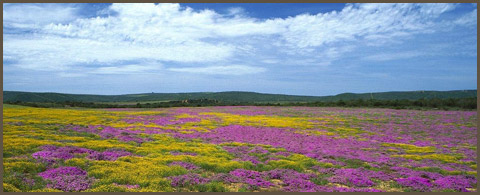
The area is known worldwide its spectacular annual explosion of spring flowers which, for a short period every year, attracts thousands of tourists. This biome contains a number of fascinating plants, including the elephant's trunk (halfmens or "half-man"), tree aloe (kokerboom) and a variety of succulents.
The province has a wealth of national parks and conservation areas. The Kgalagadi Transfrontier Park, Africa's first cross-border game park, joins South Africa's Kalahari Gemsbok National Park to the Gemsbok National Park in Botswana. It is one of the largest conservation areas in southern Africa, and one of the largest remaining protected natural ecosystems in the world. The park provides unfenced access to a variety of game between South Africa and Botswana, over its land area of more than 3.6 hectares.
The Ai-Ais-Richtersveld Transfrontier Conservation Park spans the border with Namibia, with some of the most spectacular scenery of the arid and desert environments in southern Africa. Bisected by the Orange River, it comprises the Ai-Ais Hot Springs Game Park in Namibia, and the Richtersveld National Park in South Africa. Distinctive features include the Fish River Canyon - often likened to the Grand Canyon in the US - and the Ai-Ais hot springs.
Nowhere is the Orange River more impressive than at the Augrabies Falls, which ranks among the world's greatest cataracts on a major river. The 19 separate falls cascade over a granite plateau, dropping a total of 191 metres to a 43-metre-deep pool gouged out by the force of the water.
-
Western Cape
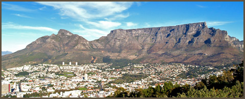
If three pyramids are the symbol of Africa's far north, then a flat-topped mountain is the symbol of its far south. Cape Town nestles in the curve of Table Mountain at the start of the hook-shaped Cape Peninsula, which ends in the jagged cliffs of Cape Point.
The Western Cape lies on southern tip of Africa. The most-southern point is not, as some maps suggest, at Cape Point; it is in fact at Cape Agulhas, some 200km east of Cape Town.
The province is one of the country's most beautiful, attracting the lion's share of foreign tourists. It is a region of majestic mountains, colourful patchworks of farmland set in lovely valleys, long beaches and, further inland, the wide-open landscape of the semidesert Karoo.
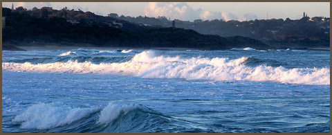
Two oceans meet on the coast of the Western Cape: the cold Atlantic Ocean is in the west, while the warmer Indian Ocean lies on the southern coast. The plankton-rich cold Benguela current flows along the west coast and is considered to be one of the world's richest fishing grounds.
With a total area of 129 462 square kilometres, the Western Cape is roughly the size of Greece. It's the country's fourth-largest province, only slightly smaller than the Free State, taking up 10.6% of South Africa's land area and with a mid-2006 population of 4.7-million people.
A potpourri of diverse cultural backgrounds gives the province a cosmopolitan flavour, creating a demographic profile quite different from the national pattern. Centuries of trade and immigration have created a population with genetic and linguistic links to different parts of Europe, southeast Asia, India and Africa. Afrikaans is spoken by the majority, with isiXhosa and English being the other main languages.
The Western Cape is topographically and climatically varied. It has a temperate southern coastline fringed with mountains; here the typical vegetation, especially in the western section, is the famed fynbos. To the north it stretches deep into the Karoo plateau, while the west coast is extremely dry.
The Mediterranean climate of the peninsula and the mountainous region beyond it is ideal for grape cultivation, with a number of vineyards producing excellent wines. Other fruit and vegetables are also grown here, and wheat is an important crop to the north and east of Cape Town.
The southern coastal area is also fertile, while fishing is the most important industry along the west coast. Sheep farming is the mainstay of the Karoo, and other forms of husbandry take place in the better watered parts of the province.
Visitors to the Western Cape can disembark at international airports in Cape Town and the city of George, or at the ports of Cape Town, Mossel Bay or Saldanha.
Saldanha, north of Cape Town, is South Africa's only natural harbour, and notable harbour for iron exports and the fishing industry. Other towns include Worcester and Stellenbosch in the heart of the winelands, George, a centre for indigenous timber and vegetable production, Oudtshoorn, known for its ostrich products and the world-famous Cango caves, and Beaufort West on the dry, sheep-farming plains of the Great Karoo.
-
Eastern Cape
The Eastern Cape, lying on the southeastern South African coast, is a region of great natural beauty, particularly the rugged cliffs, rough seas and dense green bush of the stretch known as the Wild Coast.
The province's diverse climates and landscapes range from the dry and desolate Great Karoo to the lush forests of the Wild Coast and the Keiskamma Valley, the fertile Langkloof, renowned for its rich apple harvests, and the mountainous southern Drakensberg region around the town of Elliot.
The Eastern Cape's main feature is its spectacular coastline, lapped by the temperate Indian Ocean. With long stretches of unspoilt sandy beaches, rocky coves, secluded lagoons and towering cliffs, the coast is the province's main tourist attraction.
Lying in Algoa Bay is Port Elizabeth, the largest city and an important harbour. Other major towns include Bisho, the capital; Uitenhage, which has important motor vehicle manufacturing and related industries; King William's Town, rich in early settler and military history; Grahamstown, also known as the City of Saints because of its more than 40 churches; as well as Mthatha, Graaff-Reinet, Cradock, Stutterheim, Aliwal North, and Port St Johns, the largest town on the Wild Coast.
At 168 966 square kilometres, the Eastern Cape is roughly the size of Uruguay. It's the country's second-largest province after the Northern Cape, taking up 13.9% of South Africa's land area and with a mid-2006 population of 6.9-million people.
The majority of the people speak isiXhosa, followed by Afrikaans and English.
In the Eastern Cape, various floral habitats meet. The long curve of coastline, large area and the considerable east-west and north-south distances it covers give the province extremely varied vegetation.
Along the coast, the northern tropical forests intermingle with the more temperate woods of the south, creating an interesting forest habitat of various species endemic to this region. Ancient forests are found around Keiskammahoek, Dwesa, Port St Johns and Bathurst, dune forests near Alexandria, and mangroves along the Wild Coast.
Rolling grasslands dominate the eastern interior of the province, while the western central plateau is savanna bushveld. The northern inland is home to the aromatic, succulent-rich Karoo habitat.
-
Limpopo
Limpopo is South Africa's northernmost province, lying within the great curve of the Limpopo River. It is a region of contrasts, from true bushveld country to majestic mountains, primeval indigenous forests, unspoilt wilderness and patchworks of farmland.
The province borders the countries of Botswana to the west, Zimbabwe to the north and Mozambique to the east. In the eastern region lies the northern half of the magnificent Kruger National Park, a nature reserve teeming with African wildlife in a total area roughly the size of Israel.
Limpopo is the gateway to the rest of Africa, with its shared borders making it favourably situated for economic cooperation with other parts of southern Africa.
The Maputo Development Corridor is to link the province directly with the Port of Maputo in Mozambique, creating development and trade opportunities, particularly in the southeast. Limpopo connects to the corridor via the Phalaborwa Spatial Development Initiative, a network of rail and road corridors linked to major seaports. This is complemented by airports in centres such as Phalaborwa and Musina, as well as the Gateway International Airport in Polokwane.
The capital is Polokwane, lying in the middle of the province. Further north is Modimolle, the hub of the local table-grape industry set near the beautiful Waterberg mountain range; Makhado at the foot of the Soutpansberg mountains; and Musina, with its thick-set baobab trees.
Other important Limpopo towns include the major mining centres of Phalaborwa and Thabazimbi, and Tzaneen, a producer of tea, forestry products and tropical fruit. Bela-Bela, with its popular mineral water baths, is near the southern border.
Through the centre of the province runs the Great North Road, an important route into Africa, which crosses into Zimbabwe at the major border post of Beit Bridge.
With a total area of 125 755 square kilometres, Limpopo is slightly larger than the US state of Pennsylvania. It's the fifth-largest (and fifth-smallest) of the country's nine provinces, taking up 10.3% of South Africa's land area and with a mid-2006 population of 5.4-million people.
The principal home language is Sesotho, spoken by roughly half the population, followed by Tshivenda and Xitsonga.
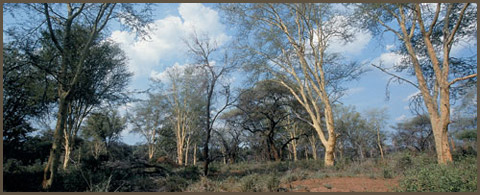
Limpopo is in the savanna biome, an area of mixed grassland and trees generally known as bushveld. A summer-rainfall region, the northern and eastern areas are subtropical with hot and humid summers and mist in the mountains. Winter is mild and mostly frost-free.
Rich in natural beauty, culture and wildlife, Limpopo has a thriving tourism industry. In addition to the Kruger National Park, there are 54 provincial reserves and several luxury private game reserves.
It's also home to the Mapungubwe Cultural Landscape, one of the country's seven World Heritage sites. South Africa's first kingdom, Mapungubwe developed into the subcontinent's largest realm, lasting for 400 years before it was abandoned in the 14th century. Its highly sophisticated people traded gold and ivory with China, India and Egypt.
Valuable archaeological artefacts have been discovered in the area, which lies on the open savannah of the Mapungubwe National Park at the confluence of the Limpopo and Shashe Rivers.
-
Mpumalanga
Mpumalanga - "the place where the sun rises" - is a province with spectacular scenic beauty and an abundance of wildlife, lying in the northeast of South Africa.
Bordered by the countries of Mozambique and Swaziland to the east and the Gauteng to the west, it is situated mainly on the high plateau grasslands of the Middleveld, which roll eastwards for hundreds of kilometres. In the northeast, it rises towards mountain peaks and terminates in an immense escarpment. In places this escarpment plunges hundreds of metres down to the low-lying area known as the Lowveld.
In the eastern region lies the southern half of the magnificent Kruger National Park, a nature reserve teeming with African wildlife in a total area roughly the size of Israel.
Mpumalanga is highly accessible, with a network of excellent roads and railway connections, as well as a number of small airports. The Kruger Mpumalanga International Airport became operational in 2002.
Nelspruit is the capital, and the administrative and business hub of the Lowveld.
Witbank is the centre of the local coal-mining industry; Standerton, in the south, is known for its large dairy industry; and Piet Retief in the southeast is a production area for tropical fruit and sugar.
A large sugar industry is also found at Malelane in the east; Ermelo is the district in South Africa that produces the most wool; Barberton is one of the oldest gold-mining towns in South Africa; and Sabie is situated in the forestry heartland of the country.
The Maputo Development Corridor, which links the province with Gauteng and the Port of Maputo in Mozambique, heralds a new era of economic development and growth for the region. As the first international toll road in Africa, the corridor is set to attract investment and release the local economic potential of the landlocked parts of the country.
With a total area of 76 495 square kilometres, Mpumalanga is slightly larger than the Czech Republic. It's second-smallest province after Gauteng, taking up 6.3% of South Africa's land area and with a mid-2006 population of 3.5-million people.
Some 30% of the people speak siSwati, the language of neighbouring Swaziland, with 26% speaking isiZulu and 12% isiNdebele.
Mpumalanga falls mainly within the grassland biome. The escarpment and the Lowveld form a transitional zone between this grassland area and the savanna biome. Long sweeps of undulating grasslands change abruptly into thickly forested ravines and thundering waterfalls of the escarpment, only to change again into the subtropical wildlife splendour of the Lowveld.
The province is a summer-rainfall area, with occasional winter snow on high ground in the escarpment. The escarpment area sometimes experiences snow on high ground. Thick mist is common during the hot and humid summers.
Sabie and Graskop provide a large part of the country's total requirement for forestry products.
These forestry plantations are an ideal backdrop for ecotourism opportunities, with a variety of popular hiking trails, a myriad waterfalls, patches of indigenous forest and many nature reserves.
Lake Chrissie is the largest natural freshwater lake in South Africa and is famous for its variety of aquatic birds, particularly flamingos.
-
KZN
The garden province of South Africa, KwaZulu-Natal is a subtropical region of lush and well-watered valleys, washed by the warm Indian Ocean. One of the country's most popular tourist destinations, the province stretches from Port Edward in the south to the borders of Swaziland and Mozambique to the north.
Its western part is marked by the dramatic Drakensberg mountain range, with several peaks well over 3 000 metres. The range has been awarded World Heritage status for its dramatic natural beauty and the wealth of San Bushman rock art found in its caves - the richest concentration on the continent of Africa.
Between the mountains and the humid, subtropical coastline is savannah grassland, but there are also areas of indigenous forest along the coast. The largest of its many rivers is the Thukela.
It is a summer rainfall area, with a climate that ranges from extremely hot along the coast in summer, to heavy snow on the mountains in winter. The Midlands are drier than the coast and can be very cold in winter.
Durban is one of the fastest-growing urban areas in the world. Its harbour is the busiest in South Africa and one of the 10 largest in the world. Every year the port of Durban handles over 30 million tons of cargo with a value of more than R100-billion. To the north of Durban, the port of Richards Bay, an important coal-export harbour, handles about 12 000 containers a year. Combined, the two ports account for some 78% of South Africa's cargo tonnage.
The capital of KwaZulu-Natal is Pietermaritzburg. The province has several popular coastal holiday resorts, such as Port Shepstone, Umhlanga Rocks and Margate. In the interior, Newcastle is well-known for steel production and coal-mining, Estcourt for meat processing, and Ladysmith and Richmond for mixed agriculture. The KwaZulu-Natal coastal belt yields sugar cane, wood, oranges, bananas, mangoes and other tropical fruit.
With a total area of 94 361 square kilometres, KwaZulu-Natal is roughly the size of Portugal. While it's the country's third-smallest province, taking up 7.7% of South Africa's land area, it has the largest population, estimated at 9.9-million people in 2006.
The principal language is isiZulu, followed by English and Afrikaans. Remnants of British colonialism and a mix of Zulu, Indian and Afrikaans traditions give the province a rich cultural diversity.
KwaZulu-Natal is the only province with a monarchy specifically provided for in South Africa's Constitution. The province's name comes from the Zulu kingdom of KwaZulu, previously a nominal (although never "independent") homeland in the apartheid era, and the former British colony of Natal, later a province of South Africa.
KwaZulu-Natal has active conservation activities. The Royal Natal National Park is home to more than 1 000 plant species, 12 species of antelope and three of the world's seven species of crane. Other reserves are Giant's Castle and the Kamberg Nature Reserve.
Some of South Africa's best-protected indigenous coastal forests are found along the subtropical coastline of KwaZulu-Natal, such as at Dukuduku and Kosi Bay. It is also along this coast that the magnificent St Lucia Estuary and Kosi Bay lakes are located. With the Drakensberg, the Greater St Lucia Wetlands Park is one of KwaZulu-Natal's two Unesco World Heritages sites.
The northern part of the province, on the Swaziland border, is typical African savanna, providing a natural backdrop for its rich wildlife, protected in several game parks.
-
Gauteng
With only 1.4% of South Africa's land area, the tiny province of Gauteng punches way above its weight, contributing 33% to the national economy and a phenomenal 10% to the GDP of the entire African continent.
Sesotho for "place of gold", Gauteng was built on the wealth of gold found deep underground - 40% of the world's reserves. The economy has since diversified, with more sophisticated sectors such as finance and manufacturing setting up shop, and gold mining is no longer the mainstay. The province is essentially one big city, with 97% of its population living in urban centres.
Johannesburg is the capital, and by far the biggest city in South Africa - and Africa as a whole. Also known as Joburg or Jozi, it is often compared to Los Angeles, with its similar urban sprawl linked by huge highway interchanges.
Johannesburg is a single municipality that covers over 1 645 square kilometres. Sydney's central municipality, by comparison, covers 1 500 square kilometres. It's been calculated that if a resident of the southern-most area, Orange Farm, were to walk northwards to the inner city, the journey would take three days.
Mine-dumps and headgear remain symbols of Johannesburg's rich past, while modern architecture abuts fine examples of 19th-century engineering. Gleaming skyscrapers contrast with Indian bazaars and African medicine shops, and the busy streets throng with fruit sellers and street vendors. An exciting blend of ethnic and western art and cultural activities is reflected in theatres and open-air arenas throughout the city.
South of Johannesburg is Soweto, developed as a dormitory township for black people under the apartheid system. Much of the struggle against apartheid was fought in and from Soweto, which has a population of over two million people.
The urban area extends virtually uninterrupted east and west of Johannesburg through a number of towns: Roodepoort and Krugersdorp on the west and Germiston, Springs, Boksburg and Benoni on the east.
To the north is Pretoria, the capital of South Africa, whose southern suburbs are slowly merging with the Johannesburg sprawl. The city is dominated by government services and the foreign diplomatic corps. It's also known for its colourful gardens, shrubs and trees, particularly beautiful in spring when some 50 000 jacaranda trees envelop the avenues in mauve.
With a total area of 16 548 square kilometres, Gauteng is slightly smaller than the US state of New Jersey. While it's the country's smallest province, it has the second-largest population after KwaZulu-Natal, and by far the highest population density - 576 people per square kilometre. (The Northern Cape, by comparison, has an average of three people per square kilometre.)
A summer-rainfall area, Gauteng has hot summers and cold winters with frost. Hail is common during summer thunderstorms.
The people of Gauteng have the highest per capita income level in the country. The province blends cultures, colours and first and third-world traditions in a spirited mix, flavoured by a number of foreign influences. The world's languages can be heard on the streets and in offices, from English to Mandarin, Swahili, French, German and more.
The province has the most important educational and health centres in the country. Pretoria boasts the largest residential university in South Africa, the University of Pretoria, and what is believed to be the largest correspondence university in the world, the University of South Africa, or Unisa.
More than 60% of South Africa's research and development takes place in Gauteng, which has 41% of the country's core biotechnology companies. It's also home to leading research institutions such as the Council for Scientific and Industrial Research, the Agricultural Research Council and the Onderstepoort Veterinary Institute.
Although the province is highly urbanised and industrialised, it contains wetlands of international importance, such as Blesbokspruit near Springs.
And it's home to the Cradle of Humankind, one of South Africa's seven Unesco World Heritage sites. The region of Sterkfontein, Swartkrans, Kromdraai and environs has one of the world's richest concentrations of hominid fossils, evidence of human evolution over the last 3.5-million years.
-
Namibia
-
Namibia Info
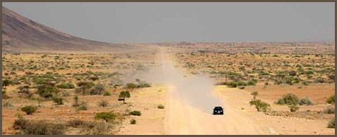
Wedged between the Kalahari and the South Atlantic, Namibia enjoys vast potential as one of the youngest countries in Africa. In addition to having a striking diversity of cultures and national origins, Namibia is a photographer's dream - it boasts wild seascapes, rugged mountains, lonely deserts, stunning wildlife, colonial cities and nearly unlimited elbow room.
A predominantly arid country, Namibia can be divided into four main topographical regions: the Namib Desert and coastal plains in the west, the eastward-sloping Central Plateau, the Kalahari along the borders with South Africa and Botswana and the densely wooded bushveld of the Kavango and Caprivi regions.
Despite its harsh climate, Namibia has some of the world's grandest national parks, ranging from the wildlife-rich Etosha National Park in Northwestern Namibia, to the dune fields and desert plains of the Namib-Naukluft Park in Western Namibia. Windhoek, in the Central Highlands, is the country's geographical heart and commercial nerve centre, with an ethnic mix of people, while surfers and beach-lovers won't want to miss Swakopmund.
Namibia is one of those dreamlike places that make you question whether something so visually orgasmic could actually exist. Time and space are less defined here. Landscapes collide. Experiences pile up. Watch a lion stalking its prey on a never-ending plain in Etosha. Fly down a giant dune on a sandboard. Spend a night alone in the desert under a sky so thick with stars you can't differentiate between constellations.
-
Botswana
-
Botswanab Info
Botswana is an African success story. After achieving democratic rule in 1966, three of the world's richest diamond-bearing formations were discovered within its borders. Today, the country enjoys a high standard of economic stability, education and health care, which, with the exception of South Africa, is unequalled elsewhere in sub-Saharan Africa.
However, its modern veneer belies the fact that much of it remains a country for the intrepid (not to mention relatively wealthy) traveller. This largely roadless wilderness of vast spaces requires time, effort and, above all else, lots of cash to enjoy it to its fullest.
Landlocked Botswana extends 1100km from north to south and 960km from east to west, making it about the same size as Kenya or France and somewhat smaller than Texas. Most of the country lies at an average elevation of 1000m, and consists of a vast and nearly level sand-filled basin characterised by scrub-covered savannah.
The Kalahari, a semi-arid expanse of sandy valleys, covers nearly 85% of the country, including the entire central and southwestern regions. In Northern Botswana, the Okavango River flows in from Namibia, and soaks into the sands to form the Okavango Delta, easily accessed via Maun. With vast open savannas teeming with wildlife, Botswana is truly the Africa of your dreams.
Because the Okavango Delta and the Chobe River provide a year-round water supply, nearly all southern African mammal species are present in the Moremi Wildlife Reserve and Chobe National Park. In the Makgadikgadi & Nxai Pans National Park herds of wildebeest, zebra and other mammals migrate annually in search of permanent water and stable food supplies.
-
Zimbabwe
-
Zimbabwe Info
In spite of an improving political situation, Zimbabwe continues to make headlines for all the wrong reasons. A power-sharing government headed by Robert Mugabe and Movement for Democratic Change (MDC) leader Morgan Tsvangirai has pledged to improve the lives of Zimbabweans.
Even though the economy is slowly improving, millions are still dependent on food aid and disease outbreaks only compound the situation.
But behind the grim data lies one of southern Africa's most beautiful countries. And despite being forced to sacrifice so much, Zimbabweans have not lost their humour or resolve. With so few visiting the country, those who do can expect royal treatment. They need you. While the world's media focuses on the fall of Zimbabwe, visitors will see a very different image of the country.
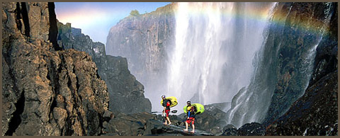
From the absolute wilderness of Mana Pools National Park, the ruins of Great Zimbabwe and the mountains looking over Mozambique in Eastern Zimbabwe, to fine dining in Harare or bungee jumping over Victoria Falls, Zimbabwe offers something for everyone.
Zimbabwe is no longer nearly as cheap as it once was, but its richness in culture and colour remain. Colonialism remains etched in all sorts of ways, but local traditions are visible. If you're willing to join a tour group, or pay and plan your own trip, then a country of charm, political intrigue and magnificent wilderness awaits. Oh, and Zimbabwe's got one of the world's best climates...even the worst government can't destroy that.
-
Mozambique
-
Mozambique Info
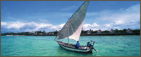
Mozambique is one of Africa's up-and-coming hot-spots, with stunning beaches, excellent diving and magical offshore islands. Go snorkelling around the Bazaruto Archipelago, sail on a dhow through mangrove channels or laze under the palms in the Quirimbas Archipelago, take an off-beat safari in the wilds of Gorongosa National Park, wander along cobbled streets past stately colonial-era buildings on Ilha de Mozambique, sip a café espresso at one of Maputo's lively sidewalk cafés (or maybe a caipirinha at one of its jazz bars), watch the silversmiths at work on Ibo Island or dance to the country's trademark marrabenta music.
For almost two decades, many of these attractions were inaccessible due to a protracted guerrilla war. Now dark times are in the past, and Mozambique is one of Africa's rising stars, with an upbeat atmosphere, overflowing markets and a 2500km coastline waiting to be discovered.
If you're inclined to something tamer, stick to Southern Mozambique, where roads and transport links (especially with neighbouring South Africa) are good and accommodation options abound.
For more adventure, head across the Zambezi into the wilds of Northern Mozambique, one of Africa's last frontiers. Getting around here takes time, but the paradisiacal coastal panoramas and sense of space, the sheer adventure of travel and - for those with a healthy budget - some of the continent's most idyllic island lodges make the journey well worthwhile.
-
Zambia
-
Zambia Info
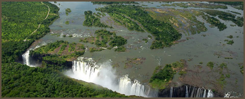
If you're out to experience the 'real' Africa, Zambia is that diamond in the rough. The country boasts some of the continent's best wildlife parks, and shares (with Zimbabwe) some of the region's major highlights: Victoria Falls in Southwestern Zambia, Lake Kariba as well as Lower Zambezi National Park in Southeastern Zambia.
It is also an angler's dream, as fishermen hail from all over the world to try their luck on the mighty Zambezi River with the hopes of landing a toothy tigerfish or the rare, giant vundu. Avid birders also flock to Zambia to glimpse its fabulous diversity of birds, most notably Chaplin's barbets.
For independent travellers Zambia can be a challenge: distances between major towns and attractions are large, and getting around by car or public transport takes time and patience. But for many, this challenge is part of Zambia's appeal.
Save Lusaka and Livingstone, this is the 'real' Africa, so rare among the increasingly developed and Westernised parts of the region.
So if you like your travel easy and your wilderness neatly bundled into a homogenised and Westernised version of 'Africa', then much of Zambia may not appeal. But if you enjoy a raw edge and an Africa with few tourists, Zambia is the place you're looking for.
|